
Ed. Note: This was posted by Betty on May 30th and will be found under comments, but I didn't want it to get lost, so here it is again.
I went by the staging area today. (5-30-09) A new chain link fence has been installed that cuts off all access from the East end of the staging area. We used to ride around the end of the fence at the edge of the canal but that is impossible now. Is riding across the bicycle bridge our only option at the moment? I was told horses were not to use the bicycle bridge, has that changed? Betty
Betty, I was just told at a recent meeting that this East end was going to be OPENED UP for us with a gate just for us...guess it didn't happen. Well, back to the city planning meetings and council meetings.
Again, I can't encourage each of you enough to 1) ride these areas 2) document with pictures 3) send pictures and letters to ALL council members and supervisors, 4) go to County and City meetings, and 5) Join equestrian groups.
Saturday, May 30, 2009
Bakersfield Life Magazine
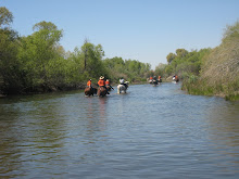
I would like to thank Bakersfield Life Magazine for their article covering the River Trail issue, http://www.bakersfieldlife.com/ . Lisa Kimble, the writer, was gracious to come out to the river with a photographer and interview quite a few interested riders. Our purpose was to bring a cross section of riders to show that we are a diverse group, that we need the river to train and condition our horses for a myriad of uses, and that it is a non-renewable resource. I would like to thank all of the riders who joined us for this purpose: Wayne Ketcherside, representing the posse, Captain of Mounted Search and Rescue, and a roper, Anthony Mungary, representing the posse, Leeann Fleetwood, representing MSAR (and top contributor for 2008), performance horses and gymkhana, Claudia Payne with daughter Morgan, representing MSAR and gymkhana, Lynn Joiner, representing Backcountry Horsemen of California as state treasurer, Kern Sierra unit president and California Wilderness Rider of 2008, Patty Montoya, member of ETI, BCHC, and MSAR, not shown: Helen Ordway, president of ETI, Roberta Robertson, co-owner of Robertson's Stables on Roberts Lane, and Marian Vargas, member of ETI and interested trail riders all!!!!!
I'd like to thank Lisa, Bakersfield Life Magazine, and all of the riders for showing up to share their concerns. We need all of the exposure we can get.
I attended a recent County Parks meeting and again heard some very encouraging news, equestrians are on the plan...and although I am the eternal optimist, I am new to this struggle. Those who have been on the forefront, although they are not giving up, are frustrated and probably more realistic than I am.
I met Bill Cooper and just received this email from him,
The public land along the river is part of the expanding Kern River Parkway. The Kern River Parkway Committee was fighting for the equestrian trail 30 years ago and still is. Through the committee's efforts there is still river access.There are some things equestrians need to consider. Carving out new routes with chain saws and other equipment is illegal. Some areas are biologically sensitive. Riparian zones are fully protected by state law.If you would like to meet wih us just let us know. We've been at this for a very long time.
Bill Cooper,
Pres.Kern River Parkway Foundation
wtcooper47@AOL
Bill, Rich O'Neil, Marci Cunningham, Carolyn Belli, and W.C. "Billy" and Roberta Robertson are but a few of the county residents who have been working hard to preserve our rights to the river trails. If it weren't for these individuals, and many others (I'd like to have their names) we wouldn't have river trails to fight for!!!
I spent quite a while with Billy today and he gave me a lot of historical information. Unfortunately, I didn't record his comments or take notes (next time I will), but I'd like to note a couple at this time: Billy told me that he has seen records as early as 1936 showing the efforts of the Kern County Rangers and Rangerettes (the early posse?) attempting to preserve a trail along the river. He also said that around 1951, Lloyd Ming, (a county supervisor?) worked with Kern County Land Company, (later Tenneco West and now Castle and Cooke), to develop an extension of Alfred Harrell Highway all the way to Stockdale Hwy and a river parkway all along the route. Too bad this didn't happen. It amazed me to learn about these visionaries. It's easy to come along now when we can see our access being lost, but for individuals in the 30's and 50's to see the importance of preserving that which was essentially "no man's" land really impressed me. Get the word out, attend meetings, help existing groups with getting involved and supporting the work they have been doing for all of US!
Thursday, May 14, 2009
JUNE EQUESTRIAN EVENTS
June 6th: Trail Ride from Rancho Rio to Ethel's, starts at 5 p.m. "Riding for the Red", organized by the Red Cross Kern Chapter. All proceeds go to the local disaster relief fund. $20 ticket includes the companionship of other equestrians, beautiful scenery through the Panorama Preserve, a tri-tip sandwich with salad or fries and a non-alcoholic drink. (Will that be one of those fantastic Old Corral Cafe tri-tip sandwiches? Why do their sandwiches taste so much better than all others? Mmmmm) There will be 50/50 tickets, door prizes...(is that a horse trailer door?) and did I mention, a lot of fun! (If I'm reading the moon phases correctly, there will be a full moon rising at 7:42 p.m. Sounds like a nice ride back in the moonlight. If you're an astronomer, let me know.) (posted 5/14/09)
Contact: 324-6427
Contact: 324-6427
Friday, May 8, 2009
East of Lake Ming
Ed. Note: The following blog may be too long for some of you, but I guarantee it has some very good info for all of us in determining the resources and problems of the trail East of Lake Ming. Thank you to Mary for hiking in and documenting this info. Also, thank you for the photos, but I couldn't grab them from the Adobe file, I'll try to get them from Mary on a disc. Someday, we will collate all of this info to present to the County and City.
From MaryNMo, VP of ETI 65. I picked the chunk of trail to explore east of Lake Ming, from that overflow parking lot behind the large group picnic area behind the golf course out there. I had done the Lake Ming to Hart Park ride several times from that parking lot, and once I had seen some people riding horses into it from a trail coming from the east, but I didn’t have time to explore it.
Also, I have friends at Robertson Stable that said that years ago they packed out from Robertson’s Stable, up Rancheria Road, all the way up to their cabin in Alta Sierra. I was just talking to one of them, Alex, the other day, and he was on that pack trip; so maybe he can find the route they used – if it hasn’t been developed over, that is.
However, this past Saturday, I took my camera and hiked that trail that heads east from that parking lot, to see if it was passable enough to explore from on horseback, and these are my findings, so you can post them to the blog.
Well, it was a good thing I didn’t take a horse, because I ran into obstacles within the first quarter mile.
Here are the pics I took, beginning at the parking lot. It is pretty much just a foot trail that fishermen use to get to fishing spots along the river, close to the river bank, and sometimes too close.
A little ways down the trail from the parking lot – good view of the river, not too close to it at this point.
Maybe a couple of hundred yards from the parking lot, fairly close together, were sizeable fallen trees. I think most horses could step over, but the logs were big enough some horses might be tempted to leap, which could cause less experienced riders to get thrown. Trail grooming would be a must here – a good chainsaw could solve these obstacles.
The next picture is of the live growth at the tip of this fallen tree – it is still alive, but the live growth may or may not be considered of significant enough value ecologically to warrant not clearing the path of the log.
The next obstacle across the trail is a low-hanging branch of a live tree. Again, this could be cleared with a chainsaw. But with this obstacle as well as with the fallen trees, there is no way around – only through. This last obstacle would render the trail impassable to horses – even with getting off and leading the horse, the branch too low to walk under and too high to step over – right smack-dab in the middle.
After this point, the trail veers uncomfortably close to the river bank, with way too sheer drop offs on the north side. The trail goes along a fairly narrow lip up against a hill. In some places, it might be possible to widen the trail or push it to the south enough to keep off the edge.
The next shot was taken a short way past the narrow area and is of a tree that had a wild hive of bees in it. I walked very quietly through the middle of the tree, which also was hanging low enough to need to be trimmed back high enough for horses to pass, but it was doable. Relocation of the hive is another issue!
In the earlier photo of those men walking on the trail, I had asked them if they knew how far the trail went. They were a group of fishermen who frequented the area and said the trail went on a bit further then there was a gate. I continued east on the trail, which continued to come too close to the sheer drop-offs to the river for my comfort til I got to an opening in a fence.
The trail had pulled inland a bit by now and I was still able to proceed – the ‘gate’ was mostly just a missing section in the fence where the wire was cut and hanging to the side.
Next, I came to an enclosure for what looked like some pumping equipment, possibly for the nearby housing developments or possibly for the golf course. There was a trail leading towards the river, that may have lead to some fishing holes, but it was so overgrown from disuse, I didn’t want to go down that way to explore it further for fear of snakes. However, I may go back with a big stick to poke vegetation before stepping into it, to see if there might be a way that a trail could be cleared through the area, since the trail to the south side of the compound goes up a steep slope, and although it is passable, it is very steep and ends up on a service road at the top of the incline.
The next photo is of the trail to the river side of the compound.
The next photo is of the trail that goes to the south and inland side of the pumping compound. It was steep, but not impossible for a fairly fit horse – I’ve been on steeper – although a rider may want to let their horse rest a few times; and there are no ledges or obstacles.
This ascent ends at a service road at the top of the incline.
The next picture is of the view across the river from the top of the hill above the pumping compound.
This next pic is of the way eastward, via the service road, toward the canyon. Can’t really see where it might go from this point – but that’s another episode.
When I was talking to those fisherman earlier on the trail, they said there were trails on the north side of the river too that they had used, but they didn’t know if development had interrupted the trails. The above picture was of what I thought I could see of some possible trails on the other side of the river.
Although I might have proceeded toward the canyon on the service road, I was out of time (and I was hiking in my riding boots and my feet were complaining) so I turned back at that point. I headed back west on the service road toward the golf course, hoping maybe to find a different route back to the parking lot, which might also be a candidate route – hopefully wider, not so close to the river drop-offs, with fewer obstacles. No such luck. I had to skirt through a utility yard at the golf course, behind the care-takers home (nice doggy, nice doggy, don’t eat me, I’m just passing through), clinging to the chain-link, hunting for a trail along the fence-line, before realizing there was none. At this point, fairly near the parking lot, my only option was to virtually ski on my boots in the loose dirt down the least steep embankment I came to, in order to descend back to the original river trail.
Synopsis and Forward Thoughts
Well, that was an adventure! I’d like to explore a few more areas in that direction on both sides of the river. I think if we can get a trail going all the way from at least Rancheria Road west to Enos Lane and then put a horse campground in the vicinity of Rancheria Road that it would provide riders to have a variety of options:
Ride up to Alta Sierra via Rancheria Road, or ride down to the horse camp from there.
Ride into the foothills near the Kern Canyon. I know there are some horse properties near the mouth of the Canyon and riders there likely know trails in the area; and the wild flowers in the spring would be a draw to the area for riders from all over the region.
Riding various portions of the Kern River Trail system. Endurance riders may want to do the whole thing (which also means we might in the future be able to attract endurance rides to be held in our area, which might be a boost to local economy). However, to have some nice doable chunks of trail for more casual riders, with nice stopping places with tie-ups, restrooms, refreshment/picnic areas, especially in the vicinity of the more picturesque areas of the river trail. Some chunks might be:
I5 to the staging area at the Aera Park (I’ve heard of a horse camp being proposed at I5, for travelers. A doable chunk during a layover on a trip, to exercise the horses, might be a nice attraction, with some sort of picnic area at Aera Park (yeah right we barely got a staging area).
Aera Park to Yokuts/Beach Park
Yokuts/Beach to Rancho Rio/Robertsons
Rancho Rio/Robertsons to Ethyls
Ethyls to Hart Park Pony Barn
Pony Barn to Lake Ming
Lake Ming to Rancheria Road
Rancheria Road to Alta Sierra (this would probably need to be broken up further)
Having rest areas at each transition point, with staging areas, where feasible, tie-ups, water for horses, picnic tables, restrooms, maybe even further development, such as snackbars/eateries, like at Ethyl’s.
Anyway, these are some of my visions for the trail system. Happy Trails to us all!!!
Friday, May 1, 2009
Upcoming events
There are several upcoming events that may be of interest to y'all:
May 9th: Volunteer Cleanup Days on the Panorama Preserve
8am-12noon
The May cleanup is sponsored by East Rotary Club. On the north side of the river we will be collecting tumbleweeds and disposing of an old wood pile and as time allows may weed and spread mulch around the young trees.We will provide water/drinks and a snack. Please bring gloves, rakes, shovels or anything you think might be helpful.
Just added:
May 9th: Golden Hills Equestrian Center Playday 8 a.m. - 5 p.m.
The horse show/play day is an open event, there are classes for 12 &
under - walk/trot and open.
May 16th: 4-H horse program
See what is going on and come to the next show, May 16, 2009. It will be held at 15259 Wible Road, Bakersfield 93313. We typically start around 8:00 a.m. ( though we have yet to be on time ). The kids compete in a broad range of jumping, english, western, reining/pattern and speed events.
May 16th: GE Appaloosa Horse Club is planning "Hoofing It For the Hungry"
A poker ride starting and ending at Ethel's Old Corral Cafe
Staging at 9 a.m., ride starts at 10 a.m.
To participate bring non-perishable foods or $5, plus $5/poker hand.
Proceeds go to the Kern County Food Bank
Contact: Dan Gilbert (661) 366-5036
Just added:
May 16th and 17th: Golden Hills Equestrian Center Equine Affaire in Tehachapi area.
contact http://www.ghequestriancenter.com/ for more information of events.
May 17th: ETI ride at Carrizo Plains (approximately 43 miles West of Maricopa)
You may see Elk and the ride is on established roads and trails with gentle slopes
Bring a lunch and water for your mount.
Free to members, $5 for non-members
Contact: Helen Ordway 706-9818 or Laura McElwee at lmcelwee@bak.rr.com
Subscribe to:
Posts (Atom)